4. Information about the generated output files
The generated output files do have the format .tif or .asc!
The TIFF-File
The Tiff-File is a 16-bit-grayscale-picutre (some tiff-viewer might have problems with that 16-bit-file!).
The highest points get the color white, the lower points get gray-values. The deepest value is almost black.
You can find a link to the official TIFF-specification on our 'downloads & links'-section.
The ArcInfo ASCII Grid format (.asc)
The values of the heightmap-color are writen into the asc-file. In our picture with about 31 mio. pixels,
it took up to 50 seconds to write this asc-file (slow WinVista with copy-bug, since Service Pack1 wasn't installed)!
But even on correct working operating systems, this step might take some seconds. Remember, that the generated .asc-file
(which is basicly a text-file) can have a size of several 100 MB!
The head of the asc-file in our program looks like this:
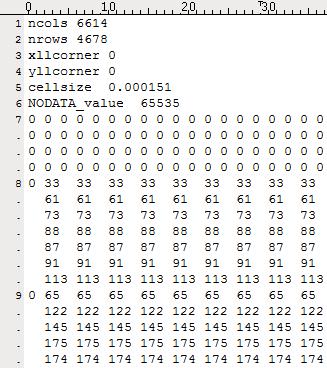
The first two rows define the width and length of the image. Lines three and four define the geograhical place in the world
of this map. These values are not set in our program. The cellsize (line 5) defines the width of one value. This was set to
1/width in our program. Line six gives an error-value, that is inserted on data-values which are unknown (we don't make use of this
in our program). Finally, the following lines give the content (4678 lines coming...).
More information can be found here
or just google the ArcInfo ASCII Grid format!